INTERVIEW | “RESCAT will help the agriculture and aquaculture sectors of the Ebro Delta adapt to climate change and prioritize more sustainable practices”
The Phi-Lab Spain team interviewed the leaders of the RESCAT project: Maria José Escorihuela, a researcher specializing in monitoring water resources using microwave remote sensing data, and Albert Garcia-Mondéjar, an engineer specializing in algorithm development for SAR altimetry missions.
RESCAT, one of the ESA Phi-Lab Spain projects, aims to develop an accessible platform to monitor the environmental status of the Ebro Delta and strengthen its resilience to climate change. It is a joint initiative by isardSAT, Lobelia Earth and Eurecat, with the participation of the Centre en Resiliència Climàtica.
Barcelona, October 2025
1. To begin, could you briefly explain what RESCAT is and its main objective?
RESCAT aims to provide an integrated tool that enhances the capacity of local stakeholders to make informed decisions and contribute to climate resilience, using the scalable case of the Ebro Delta. By integrating Earth observation data with in-situ measurements and AI-based models, it will address two main areas: measuring the impact of actions already implemented in the region and prioritizing future interventions.
2. The Ebro Delta is particularly vulnerable to climate change. What motivated you to focus your project on this area, and what makes it an ideal “laboratory” for testing resilience solutions?
The Ebro Delta is a prime location to test and demonstrate the full potential of Earth observation technology. It is a constantly evolving Mediterranean territory, a global warming hotspot, affected by environmental pressures such as coastal erosion, sea level rise, water and sediment deficits, saltwater intrusion, biodiversity loss, and other climate change-related dynamics.
Currently, monitoring systems are fragmented, and local stakeholders lack access to a unified platform that integrates data for informed decision-making.
3. What exactly does the RESCAT platform consist of, and what kind of information will it offer to users?
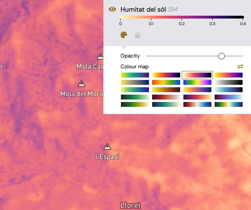
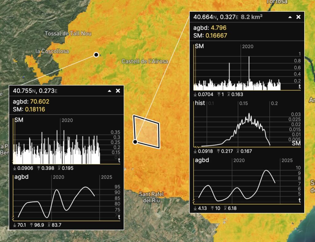
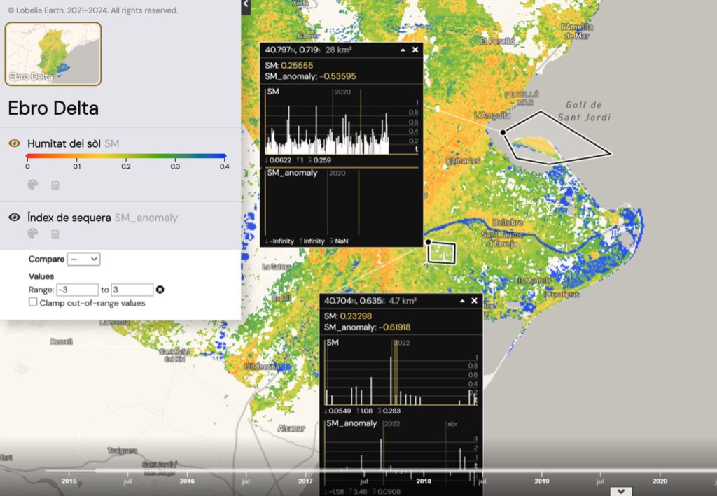
The RESCAT web platform, designed and implemented by Lobelia Earth, will be a tool to visualize and monitor key environmental parameters of the Ebro Delta and their evolution over time. These include coastal erosion, river flow, drought and soil moisture indices (developed by isardSAT), sea level, biodiversity indices, land use and cover, sea surface temperature, sedimentation, and subsidence.
4. You use satellite data and AI to monitor key variables like erosion or biodiversity loss. How is this technology translated into useful and understandable information for administrations, businesses, or citizens?
The platform will integrate and unify diverse territorial parameters, often interrelated, presenting them in a common language to answer specific questions. For example, to assess the effectiveness of sand additions to restore delta beaches and make them more resilient to sea level rise and storms, one needs information on coastal erosion, sea level rise, river flow, sedimentation, subsidence, soil moisture, drought status, and land use—over the relevant period. Or to determine which nature-based solutions are most effective for preserving wetlands, one must analyze biodiversity indices, land use and cover, river flow, soil moisture and drought indices, and sea surface temperature.
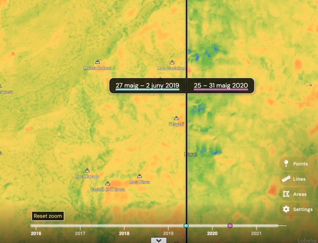
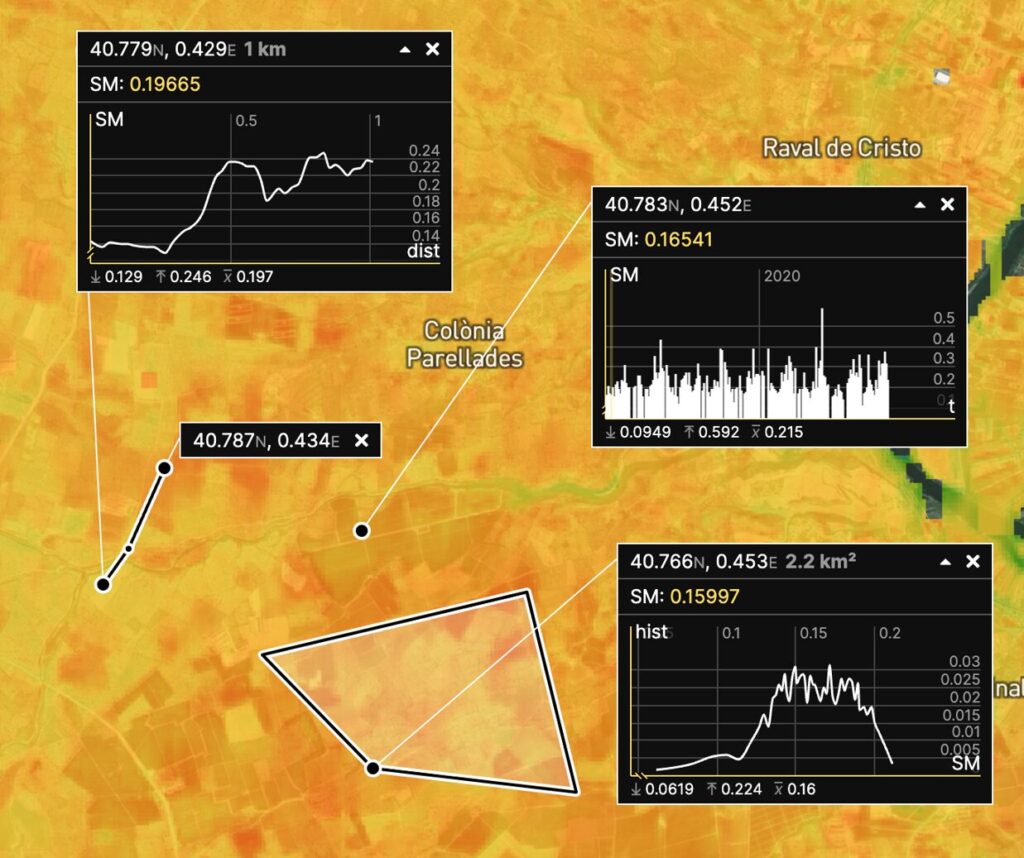
The platform will be flexible and customizable for each user. It will allow selection of various data layers, temporal comparisons, graphical visualizations, and map color customization. This design will be developed in close collaboration with local stakeholders to ensure their needs are met. Eurecat, with its long-standing connection to local agents, plays a key role in this process.
5. What concrete benefits could this tool offer to sectors like agriculture, aquaculture, or land management in the Ebro Delta?
RESCAT can provide tools to help the local agriculture and aquaculture sectors adapt to deteriorating soil and water conditions in the delta, which threaten their long-term economic viability. For example, rice producers aiming to reduce methane emissions and become more sustainable. The platform’s information will help them adapt to changing conditions, reduce losses, and prioritize the most suitable practices.
RESCAT can also offer valuable data to land management authorities who need precise, real-time, long-term data series to monitor environmental changes and design effective climate adaptation and mitigation policies. NGOs and environmental organizations, often lacking precise data to measure the effectiveness of habitat restoration efforts, will benefit too. Academic and research institutions require high-quality, validated Earth observation data to advance delta dynamics studies and predictive climate models.
6. Although the initial focus is the Ebro Delta, you suggest that RESCAT could be scalable to other vulnerable regions. Where do you envision your tool making a difference in the coming years?
The tool can be adapted to multiple regions facing climate resilience challenges, whether like the Ebro Delta or not. Initially, it could be applied to other deltaic areas like the Llobregat, Guadalquivir, Camargue, Po, or Nile deltas. It could also address more diverse issues by monitoring additional parameters—for example, in the Pyrenees and Pre-Pyrenees, facing snow and glacier retreat and avalanche risks; in the Mar Menor (Murcia), to tackle eutrophication and lagoon pollution; or in Doñana National Park (Andalusia), to address wetland loss and aquifer overexploitation.