WAVESS
Waterbody Assessment and Verification fusing Earth observation and Seabot Surveying
Introducción
WAVESS presenta un método innovador para cartografiar y monitorear las costas mediterráneas y otras masas de agua. El proyecto combina datos de observación de la Tierra (EO) con datos in situ recogidos por vehículos de superficie no tripulados (USVs), generando mapas batimétricos en tiempo casi real. De este modo, ofrece una solución escalable, sostenible y rentable ante los crecientes desafíos climáticos que afectan a las zonas costeras.
Objetivos
- Proporcionar una solución comercialmente viable para el monitoreo de áreas costeras, con foco en la cuenca mediterránea.
- Abordar la necesidad de una solución escalable, rentable y de bajas emisiones que integre datos EO con mediciones de verificación (GT), permitiendo el monitoreo costero en tiempo casi real y superando las limitaciones de los métodos tradicionales de recopilación de datos extensivos y enfoques basados únicamente en EO.
- Serve both public and private sectors through a modular and commercially viable service.
Innovación impulsada por el espacio
La novedad de WAVESS reside en su marco operativo, que garantiza fiabilidad en diversos escenarios al integrar datos EO con mediciones in situ en tiempo real, mejorando así la precisión, la resolución temporal y la adaptabilidad a entornos dinámicos.
Impacto en la resiliencia climática
La creciente frecuencia de fenómenos meteorológicos extremos, agravada por el cambio climático, subraya la necesidad urgente de contar con información oportuna de diversas fuentes para comprender y responder a estas vulnerabilidades.
WAVESS responde a la necesidad urgente de monitoreo costero preciso y frecuente frente al aumento del nivel del mar, la erosión costera y la mayor frecuencia de tormentas. El sistema proporciona datos batimétricos precisos y actualizados para apoyar la toma de decisiones en protección ambiental, planificación urbana y gestión de riesgos. Su diseño de bajo coste y bajas emisiones permite una adopción más amplia en regiones vulnerables al clima.
Del laboratorio al mercado: clientes y hoja de ruta comercial
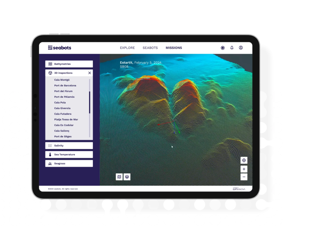
WAVESS se está desarrollando como un producto independiente listo para el mercado, validado científicamente e integrado en vehículos de superficie no tripulados (USVs), para generar mapas batimétricos y otros tipos de mapas relevantes. Este producto será lo suficientemente inteligente como para indicar a sus operadores cuántos datos de superficie adicionales se necesitan para considerar una zona de interés como mapeada, calibrada y verificada.
Gracias a la automatización, WAVESS reduce los costes operativos hasta en un 80% en comparación con los métodos tradicionales, lo que lo convierte en una opción rentable para los clientes.
Además, la solución está diseñada para ser escalable y replicable, lo que permite adaptarla a diversas regiones y sectores, maximizando así su impacto global.
Consorcio

Contacto