RESCAT
Resilience and Environmental Satellite monitoring for Climate Action and Transformation
Introducción
RESCAT tiene como objetivo proporcionar una herramienta integrada que mejore la capacidad de los actores implicados para contribuir a la resiliencia climática, utilizando como caso escalable el Delta del Ebro. Al integrar datos de Observación de la Tierra (EO) con mediciones in situ y modelos impulsados por inteligencia artificial, esta herramienta permitirá medir el impacto de las acciones ya implementadas en la zona, ayudando a priorizar futuras intervenciones.
Objetivos
- Monitorear amenazas ambientales que afectan al Delta del Ebro (por ejemplo, erosión, aumento del nivel del mar, pérdida de biodiversidad).
- Evaluar el impacto de intervenciones de protección y mejora de la resiliencia.
- Proporcionar información útil a los responsables de la toma de decisiones mediante una plataforma fácil de usar.
- Fomentar la resiliencia climática mediante la evaluación continua de los cambios en el ecosistema.
Innovación impulsada por el espacio
RESCAT innova a través de una plataforma unificada que integra observaciones satelitales y conjuntos de datos diversos —incluyendo datos EO de múltiples misiones satelitales y proveedores de imágenes comerciales— para monitorear parámetros ambientales como la concentración de sedimentos, humedad del suelo, erosión costera y aumento del nivel del mar.
Impacto en la resiliencia climática
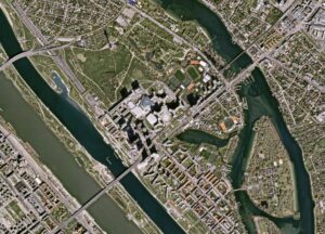
El Delta del Ebro es altamente vulnerable a impactos climáticos como la erosión costera, el aumento del nivel del mar, el déficit de sedimentos, la intrusión salina y la pérdida de biodiversidad. La creciente frecuencia de fenómenos meteorológicos extremos ha provocado retrocesos de hasta 50 metros en las líneas costeras, lo que subraya la necesidad urgente de contar con información oportuna.
Al proporcionar una plataforma de monitoreo consolidada, RESCAT mejorará la toma de decisiones, reducirá las pérdidas económicas causadas por la degradación ambiental y protegerá los medios de vida de las comunidades que dependen del Delta del Ebro. También contribuirá a garantizar prácticas agrícolas y acuícolas sostenibles y a salvaguardar la biodiversidad.
Del laboratorio al mercado: clientes y hoja de ruta comercial
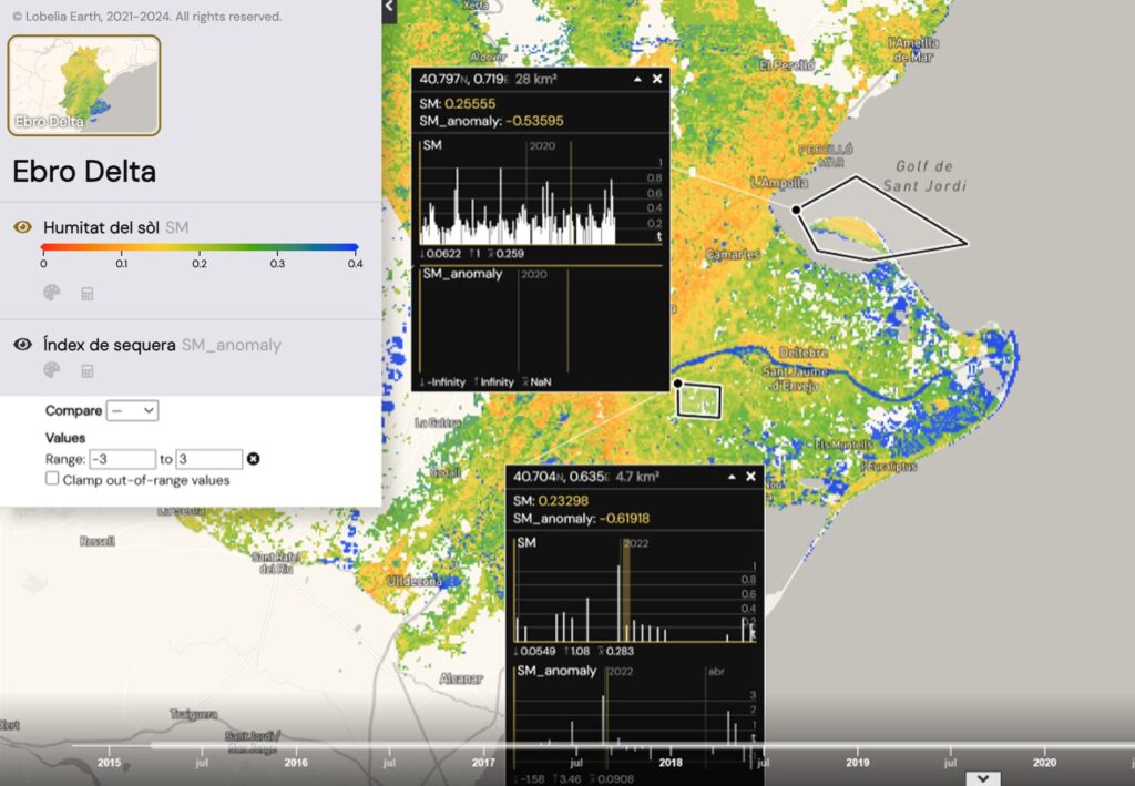
El principal resultado del proyecto RESCAT es una herramienta de monitoreo basada en la web para el Delta del Ebro que visualiza parámetros ambientales clave y su evolución en el tiempo. Esta plataforma unificada centraliza conjuntos de datos diversos, simplificando la toma de decisiones y reduciendo la dependencia de observaciones in situ fragmentadas, promoviendo así soluciones integradas y fáciles de usar.
Está dirigida a tres segmentos principales del mercado: El sector público, incluyendo agencias de gestión ambiental y costera; el sector privado, que abarca agricultura, acuicultura, seguros, energías renovables y asociaciones de usuarios de agua ; instituciones de investigación y educativas centradas en la resiliencia climática, la hidrología y el cambio ambiental.
Consorcio